“Water, water, everywhere,/ And all the boards did shrink;/ Water, water, everywhere,/ Nor any drop to drink.”, Do you remember these lines from The Rime of the Ancient Mariner by Samuel Taylor Coleridge? Perhaps your answer is in positive.
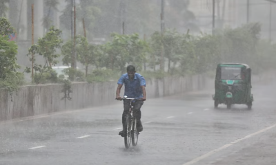
Same fate, encountered by the Ancient Mariner, also came to the life of the people of country’s northeast regions. These areas are the worst flood affected in nearly two decades and also have been hit third time this season because of relentless downpours and water rushing down from upstream. The same set of people had just starting to recover from the previous shock when fresh rains flooded the same areas.
This time it has already snatched more than 18 human lives, killed 373 cows and devastated 847 poultry farms (TBS, 21.06.2022).
“Water is all around us. I can’t find any boat to go to shelter”, said Shamsuddin Ahmed of Fatehpur area of Gowainghat upazila of Sylhet District while talking to local media when he was stranded with his family for three days.
It is worth mentioning here that the latest floods in Sylhet division have exceeded all previous records. Nearly 80 percent of areas of Sylhet division and 90 percent regions of Sunamganj simultaneously went under water , says a press release by Mostofa Kamal, PhD researcher on weather and climate at Saskatchewan University, Canada. (TBS 18.06.22).
Severe flooding like this never happened in these northeast sides of the country in the recent past. Many elderly people from local community shared that they had never seen such floods even in their entire life. Many other said such a miserable situation was not seen even during 1988 cyclone. This time More than three million people had been marooned in different upazilas of Sunamganj, Sylhet and Netrokona.
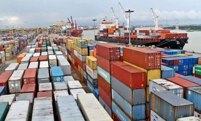
It is to be noted here that Bangladesh is a land of 160 million people. It is low-lying and frequently terrorised from natural disasters related to climate change such as floods, cyclones, storm surge, drought, tsunami etc.
The United Nations’ Intergovernmental Panel on Climate Change reports that about 17% of people in Bangladesh would need to be moved over the next decade or if that in case global warming persists at the existing rate. (The Guardian, 19.06.22).
However, such disasters often visits our country. When these calamities follow, people experience a lot of damages and losses of life. Some terms it as ghazab (wrath destined from heaven), others say ‘nature's cruel revenges’. But does the nature really retaliate without any reasons? Or is there a sensible causes behind it or human causes?
Naturally, this types of question will come on the spotlight. So what are the causes behind such types of disaster? Are these tragedy entirely natural, or does the anthropogenic causes play a major role as well? What do the experts say about it? Let’s find out!
The current flood situation turning worse across the haor regions is not entirely an outcome of heavy monsoon rains, which experts opine as the highest in history. But the high volume of rainfall getting stuck in low-lying land is also responsible for it.
However, we do know that Bangladesh has seen even higher rainfall in 2004, 1998 and 1988. But in those years, the situation was not as fatal as in 2022. But why does it deteriorate this time?
Experts say, one of the major causes in this regard is that local people has destroyed 124 km passage from Cherrapunji (Meghalaya, India) to Bhairab (Bangladesh), which played a vital role for discharging of stormwater.
"The flood situation is getting worse because the rain water is prevented from coming down. Many infrastructures have been built near Haor areas. So the river has lost its navigability.
The downpours flow gets obstructed to move quickly," said Saiful Islam, a professor at the Institute of Flood and Water Management, The Bangladesh University of Engineering (BUET).
Now let’s look at some sources from which this ruthless downpours and water rushing have been originated. According to the Indian Meteorological Department (IMD), Cherrapunji in Meghalaya is the one of the rainiest areas in the globe. In June, it recorded the highest rainfall in 122 years.
Why this extreme rainfall in the region? Experts says, sizable deforestation is the major cause of the climate changes in this areas. Scientists also predict that due to climate changes, South Asia regions will experience 40 percent increase in rainfalls of which can be testified with some recent reports from foreign media: “World’s two wettest places – Cherrapunji and Mawsynram – in Meghalaya State…. have registered record-breaking rainfall on a June day since 1995”.(Times Now, June 18, 2022)
And truly, this changing rainfall patterns directly or indirectly affecting Bangladesh also. Recent devastating flood is the testimony of the after effect of that rainfall.
Moreover, the imbalance between deforestation and reforestation rate in Meghalaya State is also causing the top soil erosion.
As you know, Cherrapunji and Guwahati in Assam are the two low-lying areas bordering Sylhet and Kurigram districts in Bangladesh. The water starts flowing in Sylhet and Kurigram as the downstream areas of Cherrapunji and Guwahati.
The direct effect of highest rainfall of Cherrapunji and Mawsynram on Bangladesh can be exemplified by another report from The Wild Forecasting Center of the University of Maryland: 12,000 cubic meters of water per second was flowing in the Surma River in front of the Sunamganj District Council at 6 a.m. on June 17, 2022. The water level was flowing about one metre above the danger level. Bangladesh never experienced situation like this since its independence.
Now let's get back to the topic again!
In Sylhet division, most of the rivers including Surma, Kushiyara, Goyin have been filled with huge amount of silt coming with the downpours flowing down not only the tributaries and distributaries, but also the flood plains.
However, we have developed various infrastructure, including road network in the Haor area, which has blocked the drainage passage. As a result, the water cannot move quickly. As a result, rainwater is rapidly spreading to settlements and urban areas.
Let's look at an example here: The All Weather Road, which is called Abura Road by the locals. This road connects the three Haor upazilas: Itna, Mithamain and Ashtagram. It was constructed in October 2020. When Sylhet and Sunamganj get submerged, the flood water discharge route through the western region (roads), including Nikli, Bajitpur and Kuliarchar, was blocked. Why? Because of the All Weather Road. It is remarkable that this type of scenario never happened before.
Now it is easily understood that this road has destroyed the natural water flow system in these areas. This fact may be another culprit for the ongoing flash floods around the northeast regions.
In addition, the tributaries and distributaries of the Sylhet region have not been dredged for many years. But it can be reliably claimed that only an upraised riverbed alone could not cause to a 7-8 feet high water level inundating the residential area of Sylhet.
The 29km All Weather Road caused huge sedimentation on hundreds of acres of land in the northeast areas. When the northeast land is submerged, flood water can pass only through an 800-metre-wide culvert due to the existence of the Abura road. Also, the flow of Surma-Khushiyara-Kalni river flow fails to drain down the stagnant water. Because of occupation of those river banks by some local people.
Apart from this, poor waste management is also one of the main reasons and responsible for this recent inundation. Municipal waste which is produced in Sunamganj and Sylhet are all cast off in the Surma River, ultimately hindering the discharge system.
It is not only the responsibility of the government alone. As sensible citizens, urban people must carry out proper waste management too. It is high time to realise that discharging non-degradable waste can block the entire drainage system and eventually will result in deaths for the rivers. Stopping waste removal in the river bodies will substitute river dredging also.
And in consequence heavy shower with strong force can easily wash the silts out to downstream.
Thus, it is clear now, most of the present floods across the northeast Haor region are mainly due to anthropogenic causes.
The planning minister recently announced that the government will not build new roads in the Haor belt. Now, a question naturally may come to minds of conscious citizens that what will the government do with that 29km road?
The answer is actually embedded in the question - in order to solve the emerging problem, the road must be removed or cut.
When asked for some suggestions regarding short-term and midterm solutions for overflows around the haor belt, Gauhar Naeem Wara, Member Secretary of the Foundation for Disaster Forum said, "Saving people's lives is the instant solution”.
In a recent interview with local media, he further opined: "The entire drainage system around the northeast region has to be restored before the next monsoon (2023). This restoration work may include- dredging, embankment protection and other relevant works. The government has to ensure that the region will not get waterlogged in any way during the next monsoon and in future. We should not wait to implement delta plan-2100."


-20251228011000.webp)


-20260313073432.webp)


-20260311074922.jpg)


-20260308071814.webp)
-20260307073636.webp)