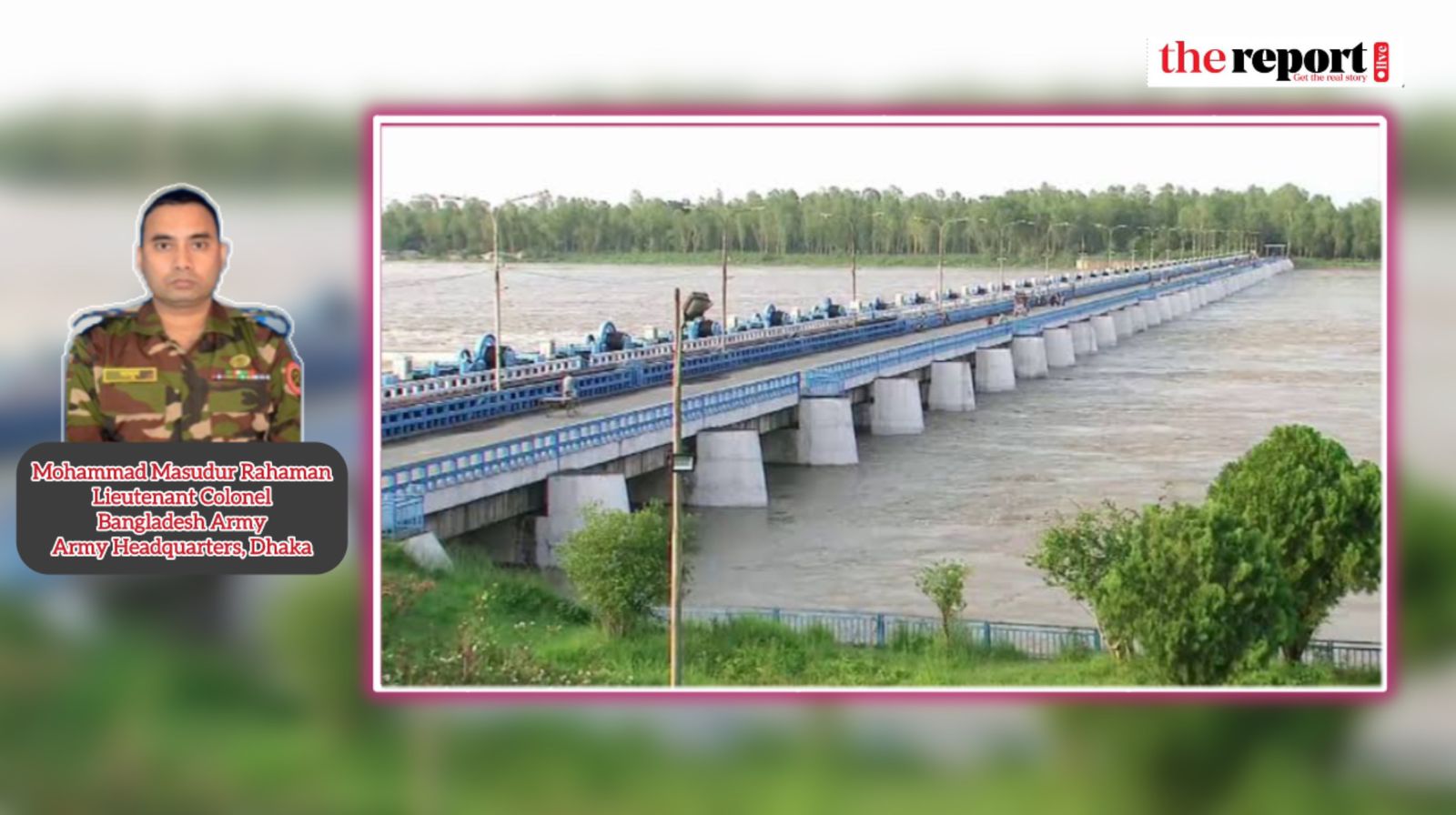
The largest of its kind in Bangladesh, the Teesta Barrage project was planned to enhance agricultural production in northern districts, a region annually facing severe water shortages, especially drought in hot summer days. The project is also meant to improve the livelihoods of rural communities, support local economic activities, conserve natural resources, reduce dependency on rainfall and groundwater, improve infrastructural development, control flood during monsoon and promote ecosystem and biodiversity conservations. Most significantly, the Teesta River is a transboundary watercourse that Bangladesh shares with India, adding a political dimension to its management. Bangladesh and India share 54 rivers. But there has been only one water-sharing agreement on one river that is ‘The Ganges Water Treaty-1996’.
The river Teesta is Bangladesh`s fourth largest transboundary river, with its floodplain spanning an area of 2,750 square kilometres in the country. But a staggering 83% of the river`s catchment area lies in neighbouring India and 17% in Bangladesh, according to hydrological report of Indian Government`s National Remote Sensing Centre (NRSC) and the Central Water Commission (CWC).
However, another estimate says the catchment area of the river spans approximately 12,540 square kilometers, with 81% in India and 19% in Bangladesh (Bangladesh Water Development Board, BWDB).
In Bangladesh, the river supports 8.5% of its population and 14% of its crop production. River also supports around 6-7 million people who depend on it for agriculture, water and overall survival.
Completed in June 1998, the barrage was constructed with a discharge capacity of 12,750 cubic meters per second, but the dry season water flow from upstream has decreased significantly to merely 36 cubic meters per second.
This drastic reduction in water flow is attributed in part to climate change, which has led to environmental shifts predicted to decrease global river water levels by 40-50% over the next several decades. More importantly, the construction of the Gajoldoba Barrage in the Indian state of West Bengal’s Jalpaiguri district in 1993, located about 60 kilometers upstream from the Bangladesh border, has diverted much of the Teesta’s water for irrigation in West Bengal. Both the farmers in India and Bangladesh are suffering from water shortages, further complicating the situation. Consequently, food and water security of northwest region of Bangladesh are significantly affected. Water security of Bangladesh highly depends on international cooperation ensuring equitable water sharing, enhancing resilience and investment in flood control infrastructure.
More about the river and the barrage
The Teesta River, a tributary of the Brahmaputra River, originates from the Teesta Kangse glacier in Sikkim, India, at an altitude of 5,400 meters above the sea level. It flows through Sikkim and West Bengal in India before entering Bangladesh, where it passes through the northern districts of Lalmonirhat, Nilphamari, Rangpur, and Kurigram, finally merging with the Jamuna River. Of the river’s total length of 414 kilometers, only 109 kilometers are in Bangladesh. The Teesta is crucial for irrigation not only in northern Bangladesh, but across parts of West Bengal.
The idea of the Barrage, located at Dalia point in Hatibandha Upazila of Lalmonirhat district in Bangladesh, was initially conceived in 1935. A feasibility report was prepared in 1960 by British engineer Haigh Zinn, focusing on irrigation and flood control in the northern Bengal. Further studies by the British consulting firm Binnie and Partners in 1968-70 led to the decision to build the barrage at the Dalia point. Finally, the construction began in 1979, and it took 19 years to complete the project.
The irrigation initiative covering the districts of Lalmonirhat, Nilphamari, Rangpur, Kurigram, Gaibandha, Dinajpur, and Panchagarh itself is a 615-meter-long concrete structure with 44 radial gates. The project includes a 110-meter canal head regulator to manage water flow, a 610-metre flood bypass, and a 2,470-metre-long closure dam. (Canal head regulators situated at the barrage or weir site regulate the water entering the main canal)
The flood embankments cover over 80 kilometers to protect the region from flooding. The project`s gross benefit area spans approximately 750,000 hectares, while the Net Irrigable Area (NIA), which accounts for the land actually available for irrigation after excluding areas such as settlements, roads and water bodies, is around 540,000 hectares. The irrigation network includes 33.6 kilometers of the main canal, 75 kilometers of the major secondary canal, 215 kilometers of the other secondary canals, 325 kilometers of tertiary canals, and 250 kilometers of drainage canals, 1,120 irrigation structures, one silt trap, and 50 drainage structures. The gross area of the irrigation project is 101,904 hectares.
What’s the barrage for?
The project`s strategic objective is to supply water from the Teesta River for irrigation during the pre-monsoon, post-monsoon, and dry seasons. It aims at boosting agricultural production in the country’s northern region that experience frequent water scarcity and often severe droughts. The project also contributes to flood control and drainage management ensuring water security of northern part of Bangladesh.
Challenges and impacts
The project faces significant challenges due to the declining water flow in the Teesta River, particularly during the dry season. This reduction is primarily caused by the upstream diversion of water in India, as well as the impacts of climate change.
Teesta’s dry period starts in October and the monsoon starts in April-May. The critical period within the Teesta is September October when supplementary irrigation is required in some areas of the river basin for agriculture. During the dry season, Bangladesh needs 8,000 cusecs, and India needs 16,000 cusecs of water. However, the Teesta River can supply only around 6,000 cusecs of water. Therefore, it is a difficult task to satisfy these demands. On the other hand, the Teesta overflows during the monsoon. Its water flow typically exceeds 300,000 cusecs to 450,000 cusecs, according to a paper of IJRSI Volume VIII, Issue I, January 2021.
The shortage of water has led to drought conditions in the region, negatively affecting crop yields and farmer incomes. The cost-benefit ratio is lowering and the farmers are facing serious financial problems as farming is getting less profitable. Consequently, food security is likely to face great challenge in future. Moreover, the river’s reduced flow has disrupted the local ecosystem, impacting fish populations and biodiversity.
Flooding during the monsoon has also become more severe due to the altered flow patterns. At Present, the difficulties and defects of the projects are conveyance loss through canal, poor condition of field outlets, long distance of canals, insufficient dredging and flood during monsoon.
Teesta river agreements
A temporary water-sharing agreement between Bangladesh and India was established in 1983, allocating 39% of the water to India, 36% to Bangladesh, and leaving the rest (25%) amount unallocated. A subsequent agreement in 1984, following a Joint River Commission (JRC) hydrological survey, revised the allocations to 42.5% for India, 37.5% for Bangladesh, and 20% unallocated. However, these agreements were never formalized into a permanent treaty. A draft treaty proposed in 2011, based on the 1984 survey, has not been implemented due to political disagreements between India`s central government and the West Bengal state government. Last state level discussion on Teesta River water sharing on June 2022, was ended without any decision.
The ways forward
Water development project is not an event but a continuous process. The dynamics of local conditions and analysis of environment demand the review of variables of the project to mitigate or adapt with the present situation. The sustainability of the project depends on securing an adequate water supply, which remains a political issue between Bangladesh and India. Without sufficient water, the project faces continuing challenges during the dry season. On the contrary, the onrush of upstream water during heavy rains in India causes severe flooding in the northern part of Bangladesh. Even the latest spell of flood in Lalmonirhat was caused by the overflowing Teesta. In late September, the Water Development Board (WDB) opened all the 44 gates of the barrage as the water level of the river increased due to onrush of upstream water and torrential rains, inundating the low-lying areas of the district.
The erosion on the river banks of the Teesta took a serious turn due to the swelling of the river caused by the torrential rainfall at that time.
Given the overall situation, here are some recommendations to address the issues:
1. International water cooperation: As the Teesta is a transboundary river, equitable water sharing is essential. Ongoing cooperation and information exchange between Bangladesh and India should be pursued, especially in sharing hydrological data until a formal treaty is in place.
2. Formalizing a water treaty: Negotiations to establish a permanent, equitable water-sharing agreement must continue to ensure the long-term viability of the barrage project. Teesta treaty should have two mechanisms: ensuring water flow during the dry period and managing water for the remainder of the year within the entire river basin.
3. Adaptation to water scarcity: Changing the crop patterns to low water-requirement crops could help farmers adapt to the reduced water flow. Efforts to educate local farmers on sustainable water use should be prioritized.
Water management projects, like the Teesta Barrage, require continuous adaptation to local conditions and environmental changes. The decreasing water flow in the Teesta River, primarily due to upstream diversions and climate change, poses a significant challenge to the project’s sustainability and water security of the country. Both Bangladesh and India are affected by the water scarcity, particularly the communities near the Gajoldoba Barrage and along the Teesta River. The increasing cost of irrigation and declining profitability for farmers threaten food security in the region.
To address these challenges, it is crucial for the Bangladesh government to continue advocating for an equitable water-sharing agreement through national and international channels. Urgent action is needed to secure the future of the irrigation project and the livelihoods of the communities it supports.
The views expressed in this article are the author’s own and do not necessarily reflect Thereport.live’s editorial stance. The author is a Lieutenant Colonel of Bangladesh Army.



-20251228011000.webp)



-20260208153007.jpeg)








-(25)-20251122062715-20260203032300.jpeg)


